Solved

Map extender universal initial zoom level

  • August 31, 2021
  • 4 replies
  • 79 views

J. de Lange
Hero
Forum|alt.badge.img+4

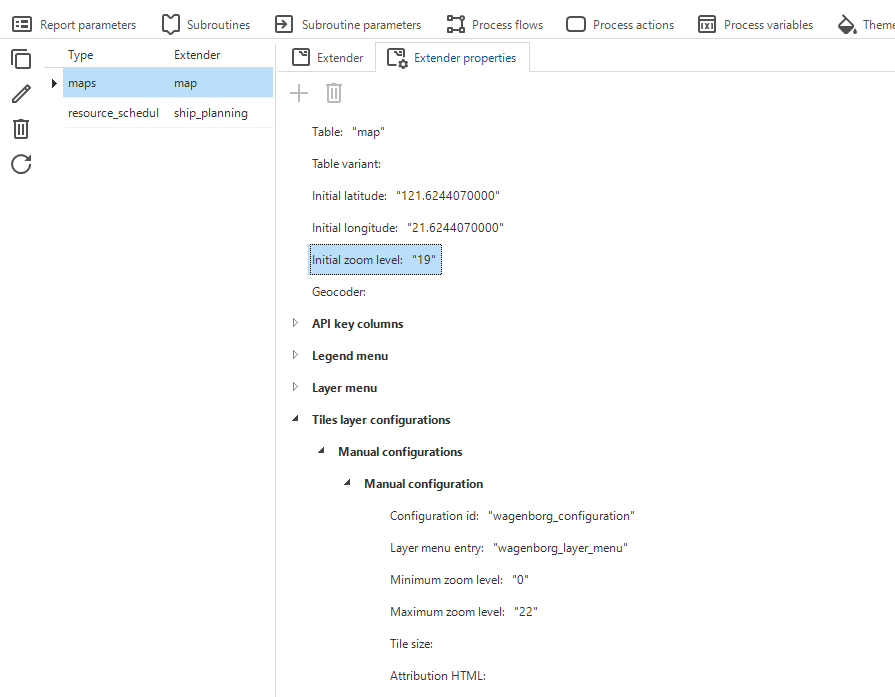
Hi, The initial zoom level of the map extender in the universal GUI doesn’t seem to work. I’ve tried several values within the range but it always opens at the same zoom level (which is very zoomed in).
Is the initial zoom level parameter not yet implemented or am I missing something?


Best answer by Mark Jongeling

Hi,

Correct, the Initial zoom level setting is not yet implemented/supported by the Universal GUI. Improvements are on the backlog for the Maps component but do not have a specific sprint/date assigned yet.

This topic has been closed for replies.

4 replies

Mark Jongeling
Administrator
Forum|alt.badge.img+23
  • Administrator
  • 4050 replies
  • Answer
  • September 8, 2021

Hi,

Correct, the Initial zoom level setting is not yet implemented/supported by the Universal GUI. Improvements are on the backlog for the Maps component but do not have a specific sprint/date assigned yet.


J. de Lange
Hero
Forum|alt.badge.img+4
  • Author
  • Hero
  • 70 replies
  • September 8, 2021

Alright, thanks for checking.


Harm Horstman
Superhero
Forum|alt.badge.img+21
  • Superhero
  • 510 replies
  • September 9, 2021

Does this functionality work then already, within the Win/Web GUI?

And same question for the Initial Longitude/Latitude properties?


J. de Lange
Hero
Forum|alt.badge.img+4
  • Author
  • Hero
  • 70 replies
  • September 9, 2021

Does this functionality work then already, within the Win/Web GUI?

And same question for the Initial Longitude/Latitude properties?

I can confirm that the initial zoom level works in the Windows GUI. Initial longitude and latitude seem to work in both the windows and the universal GUI however it will prioritize centering on plotted elements. (So it seems the initial coordinates will always be ignored if you display anything on the map)