



Open

Maps support for rotate/transform markers

Related products:Software FactoryUniversal UI
  • April 9, 2022
  • 3 replies
  • 96 views

Arie V
Community Manager
Forum|alt.badge.img+12

We would like to be able to rotate Markers on the Maps component, ideally based on a column value in the Maps view. This allows us to display our vessels in the exact direction they are heading (now they all sail east):
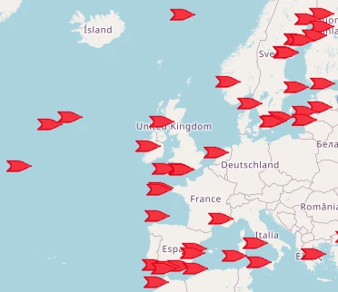
An alternative solution would be for us to use custom CSS, but due to the fact that the CSS transform property is already used by the default Maps component, we don't seem to be able to do that at the moment.


3 replies

Forum|alt.badge.img+4

Hello Arie,

The data mapping columns that you define on the Maps component have domains with elements and image combo controls attached to them. If you have the data mapping column ‘ship’, then you could add 16 elements to the domain for each of the standard compass directions (N, NNE, NE, E, etc.) with 22.5° interval rotations of your marker image. If you then ensure that the ship column has one of the 16 element database values in every row, it will display the corresponding marker image on the map. This way you should be able to approach the result you are looking for inside of the current feature set of the maps component.

I hope this helps.


Arie V
Community Manager
Forum|alt.badge.img+12
  • Author
  • Community Manager
  • April 12, 2022

@Vincent Doppenberg Yes, we have that solution planned as a workaround for the time being. But in the future we want this to be exactly correct, so that whoever is zooming in on our ships could even see them lying alongside the berth exactly as they are positioned in real life. 


Mark Jongeling
Administrator
Forum|alt.badge.img+23
  • Software Architect
  • April 13, 2022
Updated idea statusNewOpen