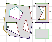



It would be a nice addition if the Maps component would support the Geometric type Multipolygon. We use the Maps component and the Geometric type Polygon to show f.e. the ECA zones at Sea. This works fine with the Polygon type, but this then also overlaps with islands in that area. The Multipolygon would allow for ‘cutting out’ inner parts of the Polygon, for example islands.